How to play
- Goal
- Know the world’s rivers: their lengths, their courses on the map, the countries they cross and where they end.
- How it ends
- River Line ends on the third mistake or when the collection runs out; every other competition ends after ten rounds, ten placements or ten pairs.
- Record
- Most correct answers, then fastest time; Length Reserve keeps the most reserve, Matching the fastest time with penalties, each with the player’s name.
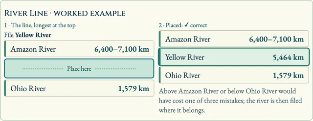
- River Line: one river starts the line with its length, longest at the top. Place each new river in the gap where its length belongs: tap a gap, then tap it again or press Place here. Lengths are ranges, and when two rivers' ranges overlap they count as equal, so either side is right. A misplaced river is filed where it belongs and costs one of three lives; the third mistake, or the last river of the collection, ends the line. Every correct placement scores one.
- Length Order: the same placement with ten rivers and no lives; most correct placements, then the faster time.
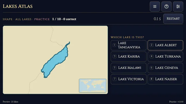
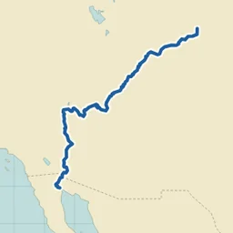
- Course: a river's course is drawn on an unlabelled map with land, lakes, borders and a small world map showing where it lies. Choose its name from eight, mostly rivers of the same continent.
- Countries: the river is named and its course drawn; exactly one of six countries lies on its main stem. The wrong ones are sovereign states, its neighbours first, so read the map.
- Mouth: choose what the river flows into: another river, a lake, a sea, an ocean, or an inland basin or desert for rivers that never reach the sea. A sea and the ocean it belongs to are never offered together, so only one answer is true.
- Length Reserve: guess ten lengths in kilometres from a reserve of 1,000. A guess inside the accepted range costs nothing; outside it, the cost grows with how many times too long or too short it is, at most 100 a guess. The Danube is 2,850–2,888 km long: 2,870 km costs nothing, 3,000 km costs 0.79 and 6,000 km costs 15.10. Highest reserve wins, with time breaking ties.
- Matching Table: pick a river, then where it ends. Match all ten pairs; each wrong pair adds three seconds, and the fastest adjusted time wins.
- The clock counts only open questions: it stops on every reveal and while a panel is open. Leaving a run, or opening the menu during one, makes it practice.
Controls
| Tap / click | Choose an answer, a gap on the line or a matching pair |
|---|---|
| 1–8 | Choose a Course answer (1–8) or a Countries or Mouth answer (1–6) |
| Up / Down · Enter | Move the gap on the line, then place the river |
| Digits · Enter | Type a length in Length Reserve; a number pad on screen works for touch and controllers |
| Arrow keys | Move around the Matching Table and the menu |
| R · H · Escape | Restart (on results: play again), open How to play, return to the menu |
| Standard controller | D-pad moves, A confirms, B goes back, X restarts, Y opens How to play, Start opens Settings, LB/RB change the collection |
Tips for River Atlas
- Length anchors The Nile and the Amazon run near 6,500–7,000 km, the Mississippi about 3,770 km, the Danube about 2,870 km, the Rhine about 1,230 km and the Thames about 340 km.
- Read the whole map The coast, the borders and the small world map in the corner tell you more than the line of the river itself.
- Start with Well-known Well-known rivers plays the 60 famous ones; All rivers and the continent collections add the rarities.
Questions about this game
Why is my favourite river missing from River Line?
A length is played only where two independent sources agree. Rivers whose sources differ by more than 15 %, or whose length depends on which headstream is counted, stay in the map and mouth competitions only.
Why does a country appear as 'on or near its course'?
Only one source puts it on the main stem, for example where a river touches a border at its source or in a lake. Such a country is never asked and never offered as a wrong answer.
Why is Matching Table missing for South America?
Most South American rivers end in the Amazon, the Paraná or the Atlantic, so ten rivers with ten unrelated mouths cannot be dealt.
River courses: HydroRIVERS v1.0 from HydroSHEDS (Lehner, B. and Grill, G. 2013, Hydrological Processes 27(15)), used under the HydroSHEDS licence. Map, coastlines, lakes, borders and countries: Natural Earth (public domain). Facts from Wikidata (CC0) with lengths cross-checked against English, German, French and Russian Wikipedia; every river links its sources from the in-game Sources panel. Opening the menu during a question, leaving the tab or restoring an unfinished run makes that attempt practice. No ads, SDKs or analytics run in the game.
Watch how to play
About River Atlas
Seven competitions on the world's rivers, from the Nile and the Amazon to the Liffey and the Molonglo. Build a line from the longest river to the shortest until your third mistake, put ten rivers in order, recognise a river from its course drawn alone on the map, pick a country it flows through, name the river, lake, sea or ocean it ends in, guess lengths in kilometres, or match ten rivers with their mouths. Worldwide score, time and player name lead the main menu.
357 rivers in eight collections: All rivers, Well-known rivers and one for each inhabited continent. A fact is played only where two sources agree: 305 lengths (two independent sources within 5 %; where reputable sources differ by up to 15 %, as for the Amazon, the range spans both and the reveal says so), the countries each main stem crosses or borders, and 181 canonical mouths. Rivers whose length depends on which headstream is measured, such as the Amur with or without the Argun, stay out of the length competitions. Courses come from HydroRIVERS and were each reviewed against the map before they are drawn.